
Like other Caribbean islands, Martinique is directly affected by a wide range of major natural hazards: hurricanes, volcanic eruptions, earthquakes, landslides, floods, coastal erosion, and lightning-related hazards[1]… are now part of our everyday vocabulary. There is, however, one hazard that is rarely discussed but is likely to become a major topic of conversation in the years to come: eustatic variations, or changes in sea level.
This risk receives little media attention today because its progression is gradual, not particularly severe, and therefore virtually imperceptible; this is what is known as a slow-onset risk.
 In reality, to understand the implications of this risk, it is necessary to conduct what historians and geographers call diachronic analyses. This essentially involves comparing facts or landscapes across different time periods. Thus, based on the coastal descriptions provided by the first settlers (sailors, chroniclers, missionaries, etc.), it appears that the coastal margins, which seem stable to us today, have undergone profound morphological and landscape changes. For example, the Reverend Fathers Labat and Du Tertre, as well as Thibault de Chanvallon, Moreau du Temple, Monnier, and others, describe the beaches of the 18th and 19th centuries as having an average width of more than 200 meters; they even note that it was possible for local residents to travel from the parish of Carbet to that of La Trinité by passing through the northern part of the island and walking along the beaches.
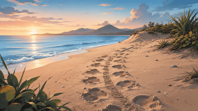
Today, coastal towns with beaches 50 meters wide are the exception; the other beaches have been reduced to mere strips that can no longer absorb the energy of the waves, are shrinking and eroding until they disappear almost entirely, endangering buildings whose foundations are increasingly at risk (buildings that, for the most part, were originally constructed about 100 meters from the current surf zone).
Is rising sea level the sole cause of this situation?
No, of course not, because over the past centuries—and especially after World War II—the people of Martinique have extracted large volumes of sediment from the beaches; the purpose was to build roads, create embankments, construct a high school… in short, there was always a good reason to extract sand from the coastal zone. Year after year, the sediment deposits have thus been depleted.
To fully understand this mechanism, it is important to know that in our region, coastal sand comes mainly from rivers (this is known as an exoreic system); however, sand miners in the northern part of the island have also, for several decades, been extracting sand from the deposits that the rivers would normally carry out to sea, before this sand is naturally deposited on the beaches. By extracting sand upstream (from the riverbeds)—sand that would have ended up downstream (in the sea and then on the beaches)—the natural sedimentary dynamics were first disrupted and then broken, and coastal erosion gradually set in.
It should also be noted that the growth of mass tourism has led to the destruction of the original coastal vegetation (spammophilous vegetation), which stabilized the shoreline; this destruction has been carried out in favor of non-native species, such as the coconut palm, which, while appealing to tourists’ imagination, does nothing to stabilize the sand, as its root system is not suited for that purpose.
Why, then, is it said that climate change contributes to the erosion of coastal areas?
In reality, climate change intensifies and exacerbates the dynamics described above. To fully understand these processes, a brief review is in order.
Before the Industrial Revolution (1860), the concentration of carbon dioxide (CO2) in the atmosphere was estimated at 260 ppmv (parts per million by volume). Today, this concentration is around 400 ppmv, and projections indicate that by 2060, it is expected to reach or exceed 410 ppmv.
The concentration of greenhouse gases (CO₂, methane, nitrous oxide, fluorinated gases, etc.) in the atmosphere traps the infrared radiation (heat) emitted by the Earth, which raises the average temperature of the troposphere[2]. Over the past 90 years, the Earth’s average temperature has risen by +0.9 degrees Celsius, and climatologists estimate that over the next 80 years, the temperature is expected to rise by +1.4 to +5.6 degrees Celsius. Under these conditions, the average sea level is expected to rise by several tens of centimeters, mainly due to the melting of high-altitude glaciers; as seawater temperatures rise slightly, water molecules will gradually expand and take up more space, setting in motion the process of seawater intrusion…
In an effort to assess eustatic variations (changes in sea level) that could affect the Caribbean coastline, a prospective analysis was conducted based on data from the IPCC[3] (April 2014). Due to current global warming, sea level in the Caribbean basin is rising by +2.5 mm annually; in reality, this figure is debatable, since some areas are currently experiencing annual increases of more than 3 mm. However, based on this conservative estimate (+2.5 mm), sea levels are projected to be about a dozen centimeters higher by 2060. While this rise may seem insignificant along a cliff-lined coast, it is by no means trivial along a nearly flat coastline; thus, even the slightest millimeter-level rise in sea level will result in seawater intrusion extending several tens of meters inland.
Given that sea levels are expected to rise by approximately +38 cm (an optimistic estimate) by the end of the 21st century, all Caribbean coastlines are therefore vulnerable.
For example, one-third of Cuba’s coastline is expected to be submerged, and the coastlines of Puerto Rico and Barbados are expected to literally disappear, while the Dominican Republic’s currently most popular coastal areas (such as Punta Cana) are expected to be nothing more than a faint memory in about 50 years. The situation is even more concerning in the Bahamas, where 80 to 85 % of the territory is expected to disappear.
All the islands of the Lesser Antilles with coastlines and low-lying coastal plains will be affected, and these are merely optimistic estimates, since a U.S. study published in March 2016 doubles (depending on the region) the projected sea-level rise.
Based on the IPCC’s optimistic scenario (a sea-level rise of +38 cm in 2090–2100), Martinique is expected to lose approximately 50 square kilometers by the end of the 21st century (Figure 1), and many coastal municipalities—such as Fort-de-France, Les Trois-Îlets, Le Vauclin, Le François, Le Robert, La Trinité, Sainte-Marie, Le Diamant, Sainte-Luce, and Sainte-Anne, as well as Le Carbet, Saint-Pierre, and Le Prêcheur—are expected to gradually shrink.
Guadeloupe is no exception, as similar studies suggest a dual trend of both vulnerability and retreat of coastal margins due to the effects of sea-level rise by the year 2100.
- Isn't it time to make this issue a top priority? Do land-use plans take these aspects into account?
- Since highly accurate simulations exist at the municipal level, wouldn’t it be desirable to finally incorporate them into urban planning and development documents?
- In Martinique, due to the island’s small size and the vulnerability of areas that could potentially be developed, our room for maneuver is very limited, and this is precisely why we should view this issue as one of the most important in the years ahead: what are we to do about the coastal populations that will inevitably have to be relocated in the near future? Where will we relocate them? Under what conditions? And with what funding?
These are all questions that remain unanswered, and for which we currently have no answers.
Nothing is lost yet; we just need to decide that this issue is a priority and do everything we can to protect coastal communities. Isn’t putting people back at the heart of the system the very essence of sustainable development?
Some Bibliographic References
– Saffache, P. 2015. “Positive eustatic variations,” pp. 35–36. In: de Caqueray, M. & Rocle, N. 2015. Coastal Risks and the Impacts of Climate Change: Why and How Should We Prepare and Adapt? Paris: EUCC, UBO, Fondation de France, IRSTEA, IFREMER, LittOcéan, 72 pp.
– Saffache, P. 2016. Estimation of Sea Level Changes in Martinique and the Insular Caribbean, and Medium- and Long-Term Consequences, pp. 89–91. In: Forum 4 Bodlanmè. 2015. Theme: «Making Our Coastline and the Sea Spaces for Sustainable Reconciliation.» Fort-de-France: Agence des 50 pas géométriques de la Martinique, 120 pp.
– Saffache, P., and Y. Pélis, 2017. Evaluation Report on the Evolutionary Dynamics of the Coastline of the City of Le Prêcheur: Marine Erosion, Intrusion, and Submersion Linked to Climate Change. S.L.: S.N. (Report commissioned by the City of Le Prêcheur), 35 p.
[1] Risk of being struck by lightning.
[2] The first gaseous layer surrounding the Earth.
[3] Intergovernmental Panel on Climate Change (IPCC).